Guthrie · Logan County
The forecast for the first capital
63°
Clear
Feels like 63° · updated 10 minutes ago
Warm A high of 91°, down to 60° tonight.
- Wind
- S 8 mph
- Gusts
- 11 mph
- Humidity
- 75%
- Dew point
- 55°
- UV index
- 0
- Visibility
- 10 mi
- Pressure
- 1,014 mb
- Cloud cover
- 0%
- Thunder, 6h
- None
The next 24 hours
60° to 91° across the window, feeling up to 91°
Now
63°
S 8
3am
62°
SSW 7
4am
62°
SSW 6
5am
61°
SSW 5
6am
61°
SSW 6
7am
60°
SSW 6
8am
62°
SSW 6
9am
66°
feels 77°
SSW 6
10am
73°
SW 8
11am
79°
SW 9
12pm
84°
SW 7
1pm
87°
SW 5
2pm
89°
SSW 5
3pm
90°
SSW 4
4pm
91°
SSW 4
5pm
91°
SSW 3
6pm
89°
SSW 3
7pm
84°
ESE 3
8pm
78°
SE 7
9pm
75°
SSE 8
10pm
73°
SSE 7
11pm
71°
feels 76°
SSE 7
12am
70°
feels 76°
S 7
1am
68°
feels 76°
S 7
- Air temperature
- What it feels like
Scroll sideways for the full window
Ten days
Bars run 56° to 91° on one scale, so days compare
-
Today Oct 7
Sunny
—60° 91° -
Thu Oct 8
Sunny
—59° 89° -
Fri Oct 9
Sunny
—58° 88° -
Sat Oct 10
Sunny
—59° 88° -
Sun Oct 11
Sunny
—64° 90° -
Mon Oct 12
Sunny
—63° 87° -
Tue Oct 13
Light rain
20%56° 69° -
Wed Oct 14
Light rain
50%56° 70° -
Thu Oct 15
Light rain
65%57° 72°
Radar
Centred on Guthrie · updated 2 minutes ago


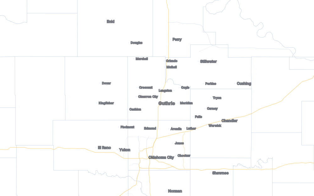
No precipitation within 75 miles of Guthrie
- Light rain 15–20 dBZ
- Rain 25–30 dBZ
- Heavy rain 35–45 dBZ
- Downpour 50–55 dBZ
- Hail likely 60+ dBZ
Last 18 minutes, 1:58 am to 2:15 am. Every town within thirty miles is named — which is why Coyle, Mulhall and Langston are on this map and not on a metro station’s.
On the ground in Logan County
Sun
7:28 am
up · down 7:06 pm
Cimarron
5.35 ft
steady · 107 cfs
Cottonwood
2.42 ft
rising · 39 cfs
Drought
Exceptional
D4 · 8.3% of the county
How we have done
Our forecast against the National Weather Service — both measured at the automated station at Guthrie Municipal
On next-day highs we have missed by an average of 3.4°; the National Weather Service by 2.2°. Across 28 days we were closer on 9, they were closer on 19.
| Made | Days | Our miss | NWS miss | Closer |
|---|---|---|---|---|
| A day ahead | 28 | 3.4° | 2.2° | 9–19 |
| 2 days ahead | 27 | 3.9° | 2.4° | 9–18 |
| 3 days ahead | 26 | 5.0° | 2.6° | 7–18 |
| 4 days ahead | 25 | 4.8° | 3.2° | 8–17 |
| 5 days ahead | 24 | 5.0° | 3.8° | 8–15 |
| 6 days ahead | 23 | 6.1° | 4.9° | 8–15 |
| 7 days ahead | 22 | 7.4° | 6.0° | 8–14 |
Day-ahead calls, most recent first — ours, theirs, and what happened
- Oct 6 we said 86° NWS 86° it was 86° +0.4°
- Oct 5 we said 81° NWS 80° it was 82° -1.4°
- Oct 4 we said 81° NWS 82° it was 82° -1.5°
- Oct 3 we said 71° NWS 74° it was 72° -0.2°
- Oct 2 we said 68° NWS 66° it was 74° -5.6°
- Oct 1 we said 77° NWS 82° it was 77° +0.1°
- Sep 30 we said 79° NWS 87° it was 86° -7.5°
- Sep 29 we said 87° NWS 91° it was 86° +1.3°
- Sep 28 we said 86° NWS 89° it was 90° -4.0°
- Sep 27 we said 88° NWS 90° it was 93° -5.2°
Both forecasts are for Guthrie’s own coordinates — ours from an AI forecasting model, theirs from the National Weather Service gridpoint at Norman — and both are scored against the same thermometer, at Guthrie Municipal (KGOK), which neither of us owns. The high is the daytime maximum, 7am to 7pm local — the window both forecasts are actually for, since the Weather Service publishes its high for the twelve hours ending 7pm and our model’s daily high is the same daytime figure. Measuring midnight to midnight instead would score a forecast against a number that can belong to the day before: on 10 September the thermometer read 88° just before one in the morning, the tail of a 104° day, and the afternoon reached only 82°. A day with too few readings is left out rather than scored from partial data. The head-to-head counts only days where both of us made a call at the same distance out — the NWS forecast runs seven days, so our eighth, ninth and tenth are not scored against it rather than counted as wins by default, and a day it did not call shows a dash rather than a victory. Nothing is filtered: every day we can verify is in, including the ones we lost.
Where this comes from
- Forecast, hourly and current conditions: WeatherNext, a machine-learning forecasting model, blended with conventional numerical weather prediction — and resolved to Guthrie's own coordinates rather than to Oklahoma City. Ten-day outlook last refreshed 1:50 am. Source: Includes weather data from Google
- How much cloud there is: measured, not modelled — the ceilometer at Guthrie Municipal (KGOK), averaged over its last half hour and read at 1:50 am, then weighed against 6 more stations around the county. A forecast model is good at temperature and unreliable about whether you can see the sun this minute, and that is the one thing a reader can check by looking out of the window. One ceilometer looks straight up and judges the whole sky from a single column of air, so on a breezy afternoon under broken cloud it can call the sky for whatever happened to drift over the airfield; the neighbouring stations are there to catch it. Rain and storms are left to the model and the radar: an instrument that counts cloud cannot see them.
- Warnings and watches: the National Weather Service office in Norman, and only the National Weather Service. A forecast model is a model; a warning is an official act.
- River stages: USGS gauges on the Cimarron and Cottonwood. Drought: the U.S. Drought Monitor for Logan County. Air quality: AirNow.